Explore the Himalayas on our interactive Himalaya map and find the trek, climb, or ski trip that interests you. The map page gives you a visual of where a Himalaya Alpine Guides expedition is located in the Himalayas, be it Nepal, India, Pakistan, or China’s Tibet. From this visual reference point you can select whether you’d like to trek, climb, or ski, and then hone in even further to trip length and time of year.

Don’t see a posted time of year, send Luke a message for the latest updates on trips.

HIMALAYA MAP PAGE

OVERVIEW

The Himalayas, or Himalaya, (/?h?m??le?.?/ or /h??m??l?j?/) form a mountain range in Asia separating the plains of the Indian subcontinent from the Tibetan Plateau.

The Himalayan range has many of the Earth’s highest peaks, including the highest, Mount Everest. The Himalayas include over fifty mountains exceeding 7,200 metres (23,600 ft) in elevation, including ten of the fourteen 8000m peaks. By contrast, the highest peak outside Asia – Aconcagua, in the Andes – is 6,961 metres (22,838 ft) tall.[1]

The Himalayan range is bordered on the northwest by the Karakoram and Hindu Kush ranges, on the north by the Tibetan Plateau, and on the south by the Indo-Gangetic Plain. The Himalayas are distinct from the other great ranges of central Asia, although sometimes the term Himalaya is loosely used to include the Karakoram and some of the other ranges. The Himalayas are spread across five countries: India, Nepal, Bhutan, China and Pakistan, with the first three countries having sovereignty over most of the range.[2] Some of the world’s major rivers, the Indus, the Ganges, and the TsangpoBrahmaputra, rise in the Himalayas, and their combined drainage basin is home to roughly 600 million people. The Himalayas have profoundly shaped the cultures of South Asia; many Himalayan peaks are sacred in Hinduism and Buddhism.

Lifted by the subduction of the Indian tectonic plate under the Eurasian Plate, the Himalayan mountain range runs, west-northwest to east-southeast, in an arc 2,400 kilometres (1,500 mi) long. Its western anchor, Nanga Parbat, lies just south of the northernmost bend of Indus river. Its eastern anchor, Namcha Barwa, is just west of the great bend of the Tsangpo river. The range varies in width from 400 kilometres (250 mi) in the west to 150 kilometres (93 mi) in the east.

CLIMATE

The vast size, huge altitude range and complex topography of the Himalayas mean they experience a wide range of climates, from humid subtropical in the foothills to cold, dry desert conditions on the Tibetan side of the range.

For much of Himalayas – that on the south side of the high mountains, except in the furthest west, the most characteristic feature of the climate is the monsoon. Heavy rain arrives on the south-west monsoon in June, and persists until September. The monsoon can seriously impact transport and cause major landslides. It restricts tourism – the trekking and mountaineering season is limited to either before the monsoon in April/May or after the monsoon in October/November (autumn). In Nepal and Sikkim, there are often considered to be five seasons: summer, monsoon, autumn (or post-monsoon), winter and spring.

Using the Koppen climate classification, the lower elevations of the Himalayas, reaching in mid elevations in central Nepal (including the Kathmandu valley), are classified as CwaHumid subtropical climate with dry winters. Higher up, most of the Himalayas have a subtropical highland climate (Cwb).

In the furthest west of the Himalayas, in the west of the Kashmir valley and the Indus valley, the South Asian monsoon is no longer a dominant factor and most precipitation falls in the spring. Srinagar receives around 723 millimetres (28 in) around half the rainfall of locations such as Shimla and Kathmandu, with the wettest months being March and April.

The northern side of the Himalayas, also known as the Tibetan Himalaya, is dry, cold and generally wind swept particularly in the west where it has a cold desert climate. The vegetation is sparse and stunted and the winters are severely cold. Most of the snowfall is in the form of snow during late winter and spring months.

Local impacts on climate are significant throughout the Himalayas. Temperatures fall by 6.5 °C (11.7 °F) for every 1000m rise in altitude. This gives rise to a variety of climates from nearly tropical in the foothills to tundra and permanent snow and ice. Local climate is also be affected by the topography: The leeward side of the mountains receive less rain while the well exposed slopes get heavy rainfall and the rain shadow of large mountains can be significant, for example leading to near desert conditions in the Upper Mustang which is sheltered from the monsoon rains by the Annapurna and Dhaulagiri massifs and has annual precipitation of around 300mm, while Pokhara on the southern side of the massifs has substantial rainfall (3,900mm/year). Thus although annual precipitation is generally higher in east than the west, local variations are often more important.

The Himalayas have a profound effect on the climate of the Indian subcontinent and the Tibetan Plateau. They prevent frigid, dry winds from blowing south into the subcontinent, which keeps South Asia much warmer than corresponding temperate regions in the other continents. It also forms a barrier for the monsoon winds, keeping them from traveling northwards, and causing heavy rainfall in the Terai region. The Himalayas are also believed to play an important part in the formation of Central Asian deserts, such as the Taklamakan and Gobi.[25]

ECOLOGY

The flora and fauna of the Himalayas vary with climate, rainfall, altitude, and soils. The climate ranges from tropical at the base of the mountains to permanent ice and snow at the highest elevations. The amount of yearly rainfall increases from west to east along the southern front of the range. This diversity of altitude, rainfall and soil conditions combined with the very high snow line supports a variety of distinct plant and animal communities. The extremes of high altitude (low atmospheric pressure) combined with extreme cold favor extremophile organisms.[26]

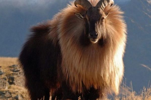
At high altitudes, the elusive and endangered snow leopard is the main predator. Its prey includes members of the goat family grazing on the alpine pastures and living on the rocky terrain, notably the endemic bharal or Himalayan blue sheep. The Himalayan musk deer is also found at high altitude. Hunted for its musk, it is now rare and endangered. Other endemic or near endemic herbivores include the Himalayan tahr, the takin, the Himalayan serow, and the Himalayan goral. The critically endangered Himalayan subspecies of the brown bear is found sporadically across the range as is the Asian black bear. In the mountainous mixed deciduous and conifer forests of the eastern Himalayas, Red panda feed in the dense understories of bamboo. Lower down the forests of the foothills are inhabited by several different primates, including the endangered Gee’s golden langur and the Kashmir gray langur, with highly restricted ranges in the east and west of the Himalayas respectively.

The unique floral and faunal wealth of the Himalayas is undergoing structural and compositional changes due to climate change. The increase in temperature is shifting various species to higher elevations. The oak forest is being invaded by pine forests in the Garhwal Himalayan region. There are reports of early flowering and fruiting in some tree species, especially rhododendron, apple and Box Myrtle. The highest known tree species in the Himalayas is Juniperus Tibetica located at 4,900 metres (16,080 ft) in Southeastern Tibet.[27]

CULTURE

There are many cultural aspects of the Himalayas. For the Hindus, the Himalayas are personified as Himavath, the father of the goddess Parvati.[28] The Himalayas is also considered to be the father of the river Ganges. The Mountain Kailash is a sacred peak to the Hindus and is where the Lord Shiva is believed to live.[29] Two of the most sacred places of pilgrimage for the Hindus is the temple complex in Pashupatinath and Muktinath, also known as Saligrama because of the presence of the sacred black rocks called saligrams.[30]

The Buddhists also lay a great deal of importance on the mountains of the Himalayas. Paro Taktsang is the holy place where Buddhism started in Bhutan.[29] The Muktinath is also a place of pilgrimage for the Tibetan Buddhists. They believe that the trees in the poplar grove came from the walking sticks of eighty-four ancient Indian Buddhist magicians or Mahasiddhas. They consider the saligrams to be representatives of the Tibetan serpent deity known as Gawo Jagpa.[31]

The Himalayan people’s diversity shows in many different ways. It shows through their architecture, their languages and dialects, their beliefs and rituals, as well as their clothing.[31] The shapes and materials of the people’s homes reflect their practical needs and the beliefs. Another example of the diversity amongst the Himalayan peoples is that handwoven textiles display colors and patterns unique to their ethnic backgrounds. Finally, some people place a great importance on jewelry. The Rai and Limbu women wear big gold earrings and nose rings to show their wealth through their jewelry.[31]

Book a Trip

Luke Smithwick’s small group exploratory climbing and skiing expeditions. Custom expeditions of any level of difficulty to any point in the Himalayas
CONTACT LUKE   BOOK A TRIP

Come skiing, climbing and trekking with us.